Kiev National University
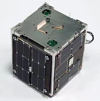
PolyITAN-1 is a project driven by Kiev National University “KPI” in cooperation with Ukrainian HAM radio community. Mission is to launch Ukrainian educational satellite build by KPI students and space exploration enthusiasts. Specific mission targets are:
- Develop, build, test, launch and operate a Ukrainian small satellite platform based on Cubesat standard.
- Conduct mission experiments with following payloads:
- Sun sensor
- Attitude position and orientation system including system software
- Test on-board GLONASS/GPS navigation subsystem
- Build ground segment infrastructure for satellite communication
- Develop and test onboard and ground telecommunication software, implement telecommunication protocols
- Establish cooperation between educational institute, space agency(s) and various government authorities, HAM radio community e.t.c.
NASA-Catalog: 40042
Downlink
437.675 MHz FM 9k6 FSK AX.25, CW
Call
MØUKP
Status
ACTIVE
Orbital Parameter
NORAD                   40042
COSPAR designator       2014-033-AJ
Inclination             97.983
RA of A. Node           132.373
Eccentricity            0.0017545
Argument of Perigee     56.855
Revs per day            14.84312838
Period                  1h 37m 00s (97.0 min)
Semi-major axis         6 994 km
Perigee x Apogee        603 x 628 km
BStar (drag term)       0.000181240 1/ER
Mean anomaly            303.435
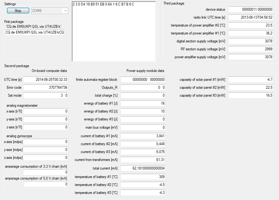
Telemetry
2014-07-20 07:56:34.570 UTC: from EM0UKP to QST (UI, payload: 17 byte)
000 > C0 00 A2 A6 A8 40 40 40 E0 8A 9A 60 AA 96 A0 61 03 F0 02 03
020 > 00 51 BC CB 51 DD 00 50 01 60 0C 0F 0C 60 0C C0

2014-07-20 07:56:34.890 UTC: from EM0UKP to QST (UI, payload: 71 byte)
000 > C0 00 A2 A6 A8 40 40 40 E0 8A 9A 60 AA 96 A0 61 03 F0 01 00
020 > 00 00 60 17 76 CB 53 03 00 00 00 00 00 00 00 00 00 00 00 00
040 > 00 00 00 00 00 00 00 16 00 0A 00 00 00 20 00 01 0F 73 02 18
060 > 74 05 D8 6E 51 39 0C BE 00 CE 00 E3 00 9D 00 A5 00 4B 05 00
080 > 00 00 00 6A 04 EF 03 F8 0E C0

2014-07-20 07:56:34.000 UTC: from EM0UKP to QST (UI, payload: 17 byte)
000 > C0 00 A2 A6 A8 40 40 40 E0 8A 9A 60 AA 96 A0 61 03 F0 02 03
020 > 00 51 BC CB 51 DD 00 50 01 60 0C 0F 0C 60 0C C0
Links und weitere Informationen
Launch
The liftoff of the 20th Dnepr rocket, took place as scheduled on June 19, 2014, at 19:11:11 UTC from an underground silo facility No. 370/13 in the Dombarosvsky ICBM deployment area in southern Russia.
The rocket carried the KazEOSat-2 (DZZ-MRES) remote-sensing satellite for the imaging of the Earth surface, which was built by the European consortium Airbus Defense and Space for the government of Kazakhstan and a cluster of 36 secondary payloads for customers from 17 countries, including Deimos-2, Hodoyoshi-3, Hodoyoshi-4, BugSat-1, SaudiSat-4, AprizeSat-9, AprizeSat-10, UniSat-6, Tigrisat, AeroCube 6, ANTELSAT, Lemur-1, BRITE-CA 1, BRITE-CA 2, NanosatC-Br1, Duchifat-1, Perseus-M1, Perseus-M2, QB50P1, QB50P, Tablesat-Avrora, 11 satellites Flock-1c, POPSAT-HIP 1, PACE, PolyITAN, DTUSat-2.