COMPASS-1 Project Fachhochschule Aachen
Am 28.04.2008 startete pünktlich und reibungslos um 0353UTC eine PSLV-C9 Rakete ins All. Es war eine internationale Mission, 10 Satelliten mit einem Gesamtgewicht von 816 kg wurden vom indischen Satish Dhawan Space Centre in Sriharikota aus in ihren Orbit gebracht. Hauptnutzlast war CartoSat-2A (690kg) und ein Microsat TWSat (Third World, 76kg), beide dienen den Fernerkundung der Erde. Zudem weitere 8 Nanostaelliten mit einem Gesamtgeweicht von etwa 50kg. Das Cluster NLS-4 bestand aus CanX-2, AAUSat-II, COMPASS, DELFI-C3, SEEDS und CUTE1.7+APD II. Der siebte Satellit (NLS-5/CanX-6) kam aus Canada und zuletzt RUBIN-8 aus Deutschland, der allerdings auf der Trägerstruktur verblieb.

Der Satellit COMPASS-1 ist eine Plattform zur Demonstration neuer Technologien. Die Payload besteht aus einer Anzahl von neuen (und noch nicht weltallgetesteten) Vorrichtungen, wie Multi-Junction Solarzellen für die Energieproduktion, einen Mini-GPS Empfänger, der die Arbeit des ACS unterstützt und einen neu entwickelten Transceiver für schnelle Funkübertragung.
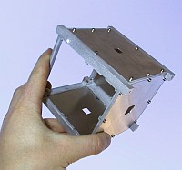
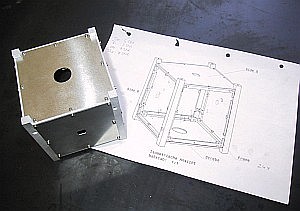
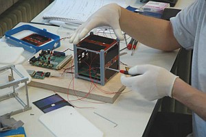
COMPASS-1 wurde von Studenten der Fachhochschule Aachen seit 2003 entwickelt. Er wiegt ca. 1 kg, seine GaAs-Solarpanele liefern eine elektrische Leistung von 2 W. Die 3-Achsen-Lageregelung erfolgt über Magnetspulen. Die Lebensdauer ist für 6 Monate konzipiert. Die Nutzlast besteht aus einem GPS-Empfänger und einer CMOS-Kamera (Auflösung von 640×480 Pixeln – VGA). Bei einer Flughöhe von ca. 640 km bildet die Farbkamera eine Fläche der Erde von 416×380 km² ab.
NASA-Catalog: 32787
Downlink
437.405 (1k2 AFSK, 2k4/4k8 FFSK/MSK AX.25)
437.275 MHz CW Bake 15wpm
Uplink
145.980 MHz (DTMF)
Call
DP0COM
Status
INACTIVE
Orbital Parameter
Name                    COMPASS-1
NORAD                   # 32787
COSPAR Bezeichnung      2008-021-E
Inklination (Grad)      97.992
RAAN                    188.798
Excentrizität           0.0014515
ARGP                    269.596
Umläufe pro Tag         14.81399211
Periode                 1h 37m 12s (97.20 Min)
Semi-major axis         7003 km
Perigäum x Apogäum      615 x 635 km
Bstar (drag Faktor)     0.000035767 1/ER
Mean Anomaly            90.359


60 Tage-Vorhersage: Illumination (Eklipsen sind schwarz) und Sonnenwinkel (rot – negativ, blau – positiv)
die COMPASS Telemetrie hat sich zum vorherigen Durchgang um 0952UTC nicht verändert. Lediglich die Batteriespannung fiel um 0.06V. Die Solarpanele liefern immer noch keinen Strom, obwohl der Satellit im Sonnenlicht ist. Die Illumination beträgt derzeit etwa 84%. Nach meinen Berechnungen bekommt COMPASS erst um den 14.05.2008 wieder 100% Licht, danach geht es wieder Bergab. Das Minimum liegt um den 13.06.2008 – dann sind es nur noch etwa 50%. Hoffen wir, dass die Batterien sich schnell und gut laden.
Dekodierung der CW Telemetrie
COMPASS-1 sendet im Nomal-Mode aller 3 Minutuen einen Telemetrieframe in CW (15 wpm). Im Power-Safe-Mode wird nur aller 8 Minuten ein Frame gesendet.

COMPASS-1 CW Bake Prüfsummenfehler 00ffffffffffffffffffffffffffffffff
COMPASS AABBBBBBBBBBCCDEFFGGHHIIJJ

AA           Solar Cells Voltage        N * 5/255         [Volts]
BBBBBBBBBB   Solar Panel 1..5 Current   N * 1.6/255*1000  [mA]
CC           EPS reset counter
D            Power Level
                0 = Battery Caacity OK
                1 = Low Battery Capacity
                2 = Critical Battery Capacity
                3 = Battery Charging
E            Heater Active
                0 = Heater OFF
                1 = Heater ON
FF           Powersafe Counter
GG           Emergency Mode Counter
HH           Battery Voltage            N * 5/255         [Volts]
II           Battery Current            N * 1.6/255*1000  [mA]
JJ           Battery Temperature                          [°C]
COMPASS-1 CW Telemetry Decoder
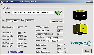
Ganz einfaches Tool zur Dekodierung der CW Telemetrie von COMPASS-1. Der empfangene String (26 Hexwerte) wird in das Textfeld eingegeben und die entsprechenden Telemetriewerte werden übersichtlich angezeigt. Die Daten können in einem ASCII File abgespeichert werden.

85270000002600212906B76300

Solar Cell Voltage:   2.61 V
Solar Panel 1 Cur:    244.71 mA
Solar Panel 2 Cur:    0.00 mA
Solar Panel 3 Cur:    0.00 mA
Solar Panel 4 Cur:    0.00 mA
Solar Panel 5 Cur:    238.43 mA
EPS Reset Counter:    0
Power Level:          Critical Battery Capacity
Heater Active:        Battery Heater ON
Power Safe Counter:   41
Emergency Mode Counter:   6
Battery Voltage:      3.59 V
Battery Current:      621.18 mA
Battery Temperature:  0 °C
Dekodierte CW Telemetrie
empfangene Telemetrie
 COMPASS-1 am 30.04.2008, 2155 CW Bake (im Hintergrund CUTE1.7+APD II Bake)
28.04.2008 1300 UTC compass 29000000000000001602c31508  BX1AD
29.04.2008 2018 UTC compass b3140100a41300210100b20702  DK3WN
29.04.2008 2155 UTC compass b3140100a41300210100b307ff  DK3WN, PE1ITR
01.05.2008 0805 UTC compass 5600000096130010... (LOS)   DK3WN
01.05.2008 1526 UTC compass 29000000000000202503c27407  9W2QC
01.05.2008 2031 UTC compass 85270000002600202906c36303  DK3WN
01.05.2008 2041 UTC compass 85270000002600212906B76300  Groundstation Aachen
01.05.2008 2216 UTC compass 85270000002600212906b66301  DK3WN
02.05.2008 0818 UTC compass 63160003010000205407cc4504  DK3WN
02.05.2008 0952 UTC compass 54000000000000216007bb5603  DK3WN
02.05.2008 1128 UTC compass 54000000000000216007b85603  DK3WN
02.05.2008 1741 UTC                  (AOS) ...10b44404  DK3WN
02.05.2008 2050 UTC compass 29000000000000000801c01504  DK3WN
02.05.2008 2054 UTC compass 51000000003000110701b43000  Groundstation Aachen
02.05.2008 2058 UTC compass 96000000005700210701b66502  Groundstation Aachen
03.05.2008 0834 UTC compass 50390000450000213205b75004  DK3WN
03.05.2008 0844 UTC compass 50390000450000203205c45004  DK3WN
03.05.2008 1151 UTC compass 62000000004200204206d13003  DK3WN
04.05.2008 1208 UTC compass c0134940180700319013bb0003  DK3WN
04.05.2008 1818 UTC compass 6010000000000021d218b45001  DK3WN
04.05.2008 1958 UTC compass 2900000000000020d719c27700  DK3WN
04.05.2008 2130 UTC compass 2900000000000000e118c01804  DK3WN
04.05.2008 2137 UTC compass 6000000070490011e218b71800  DK3WN
05.05.2008 1837 UTC compass 50000000006400007429c10001  DK3WN
05.05.2008 1841 UTC compass 57000000000700117529b35802  DK3WN
05.05.2008 1845 UTC compass 56000000001600207529.. LOS  DK3WN
05.05.2008 2010 UTC compass 29000000000000007031c01804  DK3WN
05.05.2008 2017 UTC compass 92330026090000007031c10003  DK3WN
05.05.2008 2021 UTC compass a900000060450031703... LOS  DK3WN
Mehr empfangene Telemetrie im SatBlog

Das CW Signal von COMPASS klingt recht seltsam. Ich denke, dass es am Design des Oszillators liegt. Die Erzeugung von CW (A1A) geschieht durch Ein- und Austasten des Sendesignals. Dabei wird normalerweise nicht der gesamte Sender getastet, sondern die Stufe nach der Frequenzaufbereitung. In diesem Fall wird (wahrscheinlich aus Energiegründen) der gesamte Oszillator ein/ausgeschaltet, weshalb er bei jedem Zeichen sich auf seine Nominalfrequenz erneut einschwingen muss. Und das hören wir als Zwitschern (chirp).
CW Testbake
 COMPASS-1 Testbake auf 437.275MHz
00 dp0com-compass-1-012345-compass-1
DTMF
 COMPASS-1 Quittung auf 437.275MHz
Ein korrekt empfangenes DTMF Kommando wird von COMPASS mit einem “dit” bestätigt.
1k2 AFSK
 COMPASS-1 Testpakete 1k2 AFSK auf 437.405MHz
2008-05-09 18:38:01.250 UTC: [153 Bytes KISS Frame (without CRC)]
ctrl: 3   PID: F0 {UI}   134 Payload Bytes
from DP0COM to DL0FHA:
   1 > 48 65 6C 6C 6F 20 57 6F 72 6C 64 21 20 54 68 69 73 20 69 73
  21 > 20 61 6E 20 41 78 2E 32 35 20 54 65 73 74 20 50 61 63 6B 65
  41 > 74 20 73 65 6E 74 20 62 79 20 74 68 65 20 43 4F 4D 50 41 53
  61 > 53 2D 31 20 43 75 62 65 53 61 74 2E 20 48 61 76 65 20 61 20
  81 > 6E 69 63 65 20 64 61 79 21 20 61 62 63 64 65 66 67 68 69 6A
 101 > 6B 6C 6D 6E 6F 70 71 72 73 74 75 76 77 78 79 7A 30 31 32 33
 121 > 34 35 36 37 38 39 46 48 41 41 43 48 45 4E
Hello World! This is an Ax.25 Test Packet sent by the COMPASS-1 CubeSat. Have a nice day!
abcdefghijklmnopqrstuvwxyz0123456789FHAACHEN
________________________________________________________________________________

2008-05-09 18:38:05.520 UTC: [153 Bytes KISS Frame (without CRC)]
ctrl: 3   PID: F0 {UI}   134 Payload Bytes
from DP0COM to DL0FHA:
   1 > 48 65 6C 6C 6F 20 57 6F 72 6C 64 21 20 54 68 69 73 20 69 73
  21 > 20 61 6E 20 41 78 2E 32 35 20 54 65 73 74 20 50 61 63 6B 65
  41 > 74 20 73 65 6E 74 20 62 79 20 74 68 65 20 43 4F 4D 50 41 53
  61 > 53 2D 31 20 43 75 62 65 53 61 74 2E 20 48 61 76 65 20 61 20
  81 > 6E 69 63 65 20 64 61 79 21 20 61 62 63 64 65 66 67 68 69 6A
 101 > 6B 6C 6D 6E 6F 70 71 72 73 74 75 76 77 78 79 7A 30 31 32 33
 121 > 34 35 36 37 38 39 46 48 41 41 43 48 45 4E
Hello World! This is an Ax.25 Test Packet sent by the COMPASS-1 CubeSat. Have a nice day!
abcdefghijklmnopqrstuvwxyz0123456789FHAACHEN
1k2 AFSK Testpaket auf Anforderung
Housekeeping Data
 COMPASS-1 HK Data auf 437.405MHz, 1k2 AFSK
2008-05-11 21:18:33.890 UTC: [153 Bytes KISS Frame (without CRC)] ctrl: 3 PID: F0 {UI} 134 Payload Bytes from DP0COM to DL0FHA: 1 > 00 1A 53 00 00 9F 17 00 00 00 03 00 64 00 13 11 10 07 0E 01 21 > 00 FF 9F 00 A0 01 A0 06 00 00 00 0F 00 53 00 00 9F 29 00 00 41 > 00 03 9E 61 27 00 00 00 FF 00 FF 00 FF 00 FF 34 00 02 D0 00 61 > 06 00 3E 00 7F 00 05 17 21 05 40 04 04 00 7F 80 0F 1F 00 FF 81 > D1 FF CC FF CD FF DC FF C8 FF F5 00 16 36 00 00 1B 00 00 00 101 > F0 41 00 00 00 00 00 00 00 00 00 00 00 00 00 00 00 00 00 00 121 > 00 00 00 00 00 00 00 00 00 00 C5 1B 91 EA ________________________________________________________________________________ 2008-05-11 21:18:42.830 UTC: [153 Bytes KISS Frame (without CRC)] ctrl: 3 PID: F0 {UI} 134 Payload Bytes from DP0COM to DL0FHA: 1 > 00 1C 53 00 00 A0 17 00 00 00 03 00 5E 00 1C 11 10 07 0E 01 21 > 00 FF A0 00 A0 01 A0 06 00 00 00 0F 00 53 00 00 A0 29 00 00 41 > 00 03 9E 61 25 00 00 00 FF 00 FF 00 FF 00 FF 21 00 00 D1 00 61 > 0C 00 07 00 7F 00 04 FE 06 FE 40 04 04 00 7F 80 0F 1F 00 FF 81 > D1 FF CC FF CF FF DD FF C8 FF F5 00 16 36 00 00 1B 00 00 00 101 > F0 4A 00 00 00 00 00 00 00 00 00 00 00 00 00 00 00 00 00 00 121 > 00 00 00 00 00 00 00 00 00 00 C5 1B 91 EA
Homepage und weitere Informationen
http://www.raumfahrt.fh-aachen.de/
WDR Mediathek (sehr interessantes Video)
http://www.innovations-report.de/html/berichte/physik_astronomie/bericht-108913.html
QSL Karte
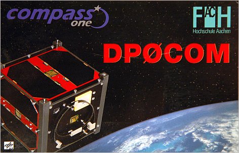

COMPASS ONE
c/o Thomas Hoevelmann
Hasencleverstr. 32
D-52222 Stolberg
Germany
Launch
| Flight Sequence ====================================== T=0.0s PS1 Ignition T=113.14s PS1 Separation (h=50.42km) T=113.34s PS2 Ignition (h=50.60km) T=188.14s Heat shield separation T=264.04s PS2 Separation (h=204.18km) T=265.14s PS3 Ignition (h=205.56km) T=524.24s PS3 Separation (h=507.48km) T=540.0s PS4 Ignition (h=518.42km) T=844.2s PS4 Cut off (h=637.66km) + 37.0s Cartosat-2A separation + 47.0s Reorientation of PS4 starts + 67.0s Reorientation of PS4 ends + 82.0s TWSAT separation +122.0s Reorientation of PS4 starts +142.0s Reorientation of PS4 ends +200.0s CanX-2 separation +220.0s Cute 1.7+APD II separation +240.0s Delfi-C3 separation +260.0s AAUSat-II separation +280.0s COMPASS-1 separation +300.0s SEEDS separation 0353 UTC — Launch of PSLV-C9 (-0/+10 min) 0430 UTC — Injection elements from LV INS 0500 UTC — First NORAD sensor track 0600 UTC — NORAD element set published |   |